I woke up early in the morning in a bay overlooking Floreana.

We are moored across from a sandy beach, known as “Post Office Bay”. I spot fresh turtle tracks — a female climbed onto the beach, dug a nest, laid eggs, covered them and returned to the sea.

We start our day with a wet landing on the beach. The plan is to go snorkeling, but first we go to the “post office”. This is a barrel located about 10 meters inland from the high water mark.

According to the story, pirates and whalers set up the barrel as an informal post office. They would deposit letters addressed to their family. A ship heading home would take letters for its destination port. In modern days this site became an experiment in social networking. Visitors to the Galapagos would leave a postcard, and collect ones they can deliver in person when they return home.

The barrel today is a modern reconstruction of the original. The postcards are kept in large ziplock bags. David recovered these from the barrel and distributed among us to go through them. There was an interesting coverage of countries represented, although the majority were US and Europe.
After finishing with the barrel, I took few pictures of the remain of a sardine canning factory that used to be here.


By now it was hot in the wetsuit, and going snorkeling is a welcome diversion. The water is a bit colder, due to the Humboldt current from the south. The current also brings nutrients, and the rocks here are covered with rich weed growth.

Someone shouts “turtle!” and we all converge on a turtle slowly eating the weed. I photograph it, and then notice another turtle. Soon we realize that the water is turtle infested. In a single glance I could see 5 or 6 turtles.


As we snorkel along we keep running into turtles. This seems to be a turtle convergence point.


Suddenly a dark shape passes my field of view. A sea lion. Unlike our previous encounter, this is an older sea lion. It zoom among the snorkelers to check us out and then disappear into beyond the visibility range.

Few minutes later it reappears, circle us, and then continues. This pattern repeats several times.


 |
| Sun star |
 |
| Abstract patterns |
After about an hour of snorkeling we start returning to the beach. We are all there, and David sits on the side enjoying the sun. At some point I see that he is trying to play with his walkie-talkie. It turns out that he cannot reach the ship crew to let them know we are ready for pickup.
We look toward the ship and it seems that no one is on deck. We sit on the beach and seem to be forgotten. This is weird as usually the schedule is relatively punctual. Few more minutes pass, and then David decides he will swim to the ship (about 100m-150m or so). He barrows my wetsuit for that. He swims out, and after 20min or so returns with the two pangas. I am still not sure what happened there.
The pangas do not take us to the ship, but rather we take a tour along the coast. This part of the island has many rocky outcrops along the coastline. Some are just few rocks, others are almost mini islands with a small sandy beach. Among these rocks we see marine iguanas.

We also see colonies of sea lions, with the characteristic social structure — a large male and few females with their young. The male is constantly patrolling his territory and announcing loudly his presence.


 |
| Nice and comfy on the rocks |

During the ride we encounter turtles swimming around us.


 |
| Jon trying underwater photography from the panga |
We pass mangroves on the water edge and large cacti slightly more inland.

David takes onto a small beach and goes out to bring a fistful of sand. He shows us that this greenish sand — to me it looks brown. It is clearly different from the white sand on most beaches we have been to.

We enter a shallow bay lined with mangroves. We spot sharks in the water. Few of them swim by. As we get closer to the mangroves, we see many white-tip reef sharks reseting among the roots in the shallow.

 |
| My feeble attempts at underwater photography from the panga |

By now we see our afternoon’s site, a rock structure called “The Devil’s Crown”.
 |
| Devil's Crowns |

 |
| Boobies! |
 |
| Frigate flyby |

The ship has moved during our panga ride and is moored here. We reach the ship and take a lunch break.
Our next activity is snorkeling at the Devil’s Crown. David draws a detailed map of the crown, including the current directions. Sadly, I did not photograph the map, but here is my reconstruction based on Google Earth images.
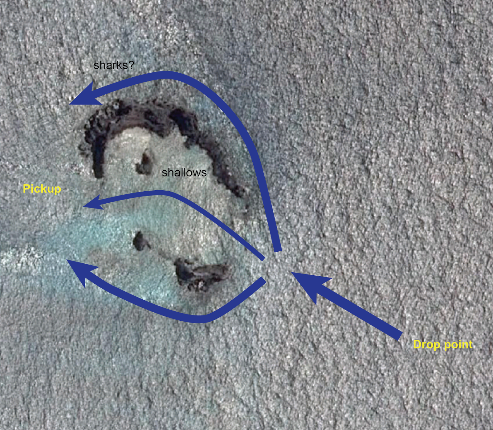
The plan was to drop us from the panga ~100m before the crown, and then making sure we get into the structure rather than taken away by the current. We were then to climb back into the panga, and redo this, but this time going around the outer face of the crown. David kept emphasizing the importance of staying as a group and making sure to get to the right direction at the critical splitting point at the entry to the crown.
We took the pangas and went to the planned location, even further out for safe measures. We all jumped and started puddling. After a while it was clear we are working hard but not getting anywhere. The current is non-existent, or even in the opposite direction.
We all went back onto the pangas, and it drove us to the entry to the crown. There we saw the pangas of another tour sitting calmly in the water.
We jump into the water, and go into the crown. David leads the group in a mad dash toward the other end. At this point there is some current going against us (opposite the direction in the plan). This dash is no fun, burns energy and we do not get to see anything.
We reach the other side of the crown, and I catch up to David and tell him that people are straggling to keep up with him and that there is no reason to rush. He retorts that if “you are not fit for snorkeling, you should have stayed in the boat”. I give up on the hot head, but angry inside.
The kids spot an eagle ray going below us, and I manage to capture it although it is quite deep at this point.


A young sea lion shows up and starts to play with us.


We are called to board the pangas for the second leg of the snorkeling. Now the pangas bring us to the outer side of the entry, and we go along the outer edge. Here there is a sharp cliffs and crags going into deeper water.
 |
| A large marble ray below us |
 |
| Spot the fish? |
About 2/3 of the way around we reach a pinnacle going up in the water. There are a lot of fish schools about. According to the plan we should have seen sleeping sharks somewhere here, but except for two sting rays, do not meet the sharks.


Again we go onto the pangas, and return to the inner side. This time around I ignore David and go exploring. There is a layer of fish carpeting the shallow bottom of the entry. They all face the current and keep low. When a bigger fish swims through the crowd open up to maintain respectable distance from it.


In one of the rocks in the middle of the structure I see a small cave. I look inside and see passage to the other side.
Our time is up and we need to continue. We return to the ship, change, and go for a trip on the shore just next to the crown.
This area is called Cormorant Point, although there are no cormorants here.
We land on a beach with many sea lions. They ignore us.


We continue inwards on trail that leads us around a large salt marsh. This is a prime flamingo territory, but sadly, we do not encounter any this time.

The trails goes on toward the other side of the small peninsula, and we reach a sandy beach.

This beach is known for the rays that come close to the water edge. Today there are waves, and we do not spot rays. Either they are not there, or the waves obscure them.


We go along the beach searching for sights. It is beautiful but barren.


We start to get a little bored, and the kids find a new way to burn energy.

By now the sun is almost down, and the golden hour is upon us. On the way back to the landing point we see beautiful sunset over the marsh.


No comments:
Post a Comment