Saturday, July 16, 2011

Iceland Chronicles - Part IV (Glaumbaer and Skagafjorder)

Today we continued Going Eastwards along the north coast of Iceland. 


We drove for a while along the ring road, passing the town Blonduos, where we did some shopping and marveled about the ugliness of their church (built to resemble a volcano).

The ring road passed through green valleys and circumvent a peninsula. When coming down toward the sea level we stopped at a memorial to an Icelandic poet (who lived most of his life in Canada) and watch the view.

Soon after, we departed from the ring road and drove north to a place called Glaumbaer. It is an old farmhouse that was turned into a museum. It shows houses from several centuries ago. They are built of wooden frame that hold grass and peat that form an organic wall. The place looked and felt like one would imagine a hobbit house, although it lacked round windows, and I expect that the hobbit have better floors.


The house contains quite a few artifacts from day to day live of people from that time. Simple things like beds, cabinets, work tools, ice-skates, and such.


After the museum we crossed the end of the Skagafjorder (a fjord), and went up its east coast. We stopped at the town of Hofsos for lunch (fish and chips for the adults, and hamburgers for the kids).


This town is the home of the "Emigration Center" where people from Icelandic origin can find out the genealogy of their family. We decided to skip this part, and continued driving along the impressive coastline. At the north end of the peninsula, after a short tunnel, we reached the town of Siglufjorder. This is one of the northern most towns in the area, and during the early 20th century was the Herring Capital of Iceland.


Upon arriving we found that the Herring Museum just closed. And so we missed the main attraction in town. The campsite was quite full, it seems that many Icelanders go camping on the weekend, and here there were several groups that looked like large family reunions.


We decided to push on to the next campsite. This meant driving through a fairly new pair of tunnels (each about 7km long) to the town of Olafsfjorder. Here the campsite was also full, and so we continued on to the next town over, another 8km tunnel, this one with one lane, and turn off bays every ~50m, so that cars going in the opposite direction have to stop to let us pass (we were going in the direction with right of way). Going over breathtaking cliffs, we reached the town of Davlik. Here there was a large mostly empty campsite. But, the shower was broken, and moreover, once we got outside a strong smell of fish hit us. We debated whether to stay and get used to the smell, or seek another location.

At the end, we decided to go back to Siglufjorder, driving three tunnels, where in one of them we have to move aside whenever there was a car in the opposite direction (kind of nerve wrecking to estimate when is the right time to pull aside). In the end we returned to the place we started and parked there. It was actually a nice camp ground, and we found a spot off to the side that was not too crowded. We saw extended families that camped together and did all kind of social games that we didn't know.


Somewhere during the afternoon the harsh wind stopped and we had a quiet and comfortable night.

Friday, July 15, 2011

Iceland Chronicles - Part III (Vatnsnes Peninsula)

Throughout the night the wind was howling and rocked the RV. Yael claimed that she felt like a baby rocked to sleep and had the best sleep so far. Outside was a clear day with very strong wind. (We later found out that wind from the arctic was blowing through all of Iceland during these days.)


After breakfast we set on the road. Today we had to cross back to the main ring road, which was about 150 of driving. Once we went past Stykkishólmur the road turned into a gravel road. For the next two hours we drove through hills raising a large dust cloud behind us.


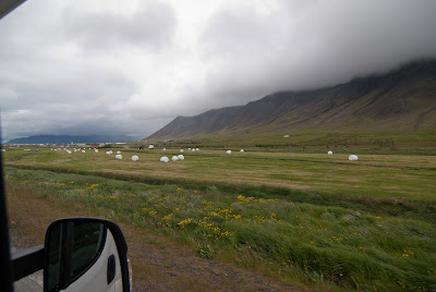
The impressive thing about Iceland so far, is the common nature of the view along the roads. For most of the time, the roads run next to fenced fields that either serve as grazing ground for sheep, horses, or less often cows, or are freshly harvested grass/grain fields. These are dotted with big bundles of hay wrapped with white plastic. We call them the "mozzarella" fields as these bundles remind us of mozzarella balls.
The number of horses we see is huge. Makes us wonder what they do with all the horses. The guide book say they are used for tourism and for herding the sheep in the autumn. But, the numbers seem to large for that (we keep seeing huge herds).

It seems that all the land that is even remotely potentially reachable by vehicle is partitions among farms. Along the roads there are small ways that lead to each farm. These are marked with the name of the farm, and the detailed maps lists all the farms.

After a while the road improved, and drove a while on, until we reached a gas station on the intersection of the ring road and the road to the west fjords. We had McIceland burgers, and then continued on the ring road north.

We decided to go watch seals and seabirds in a small peninsula of Vatnsnes. The road was gravel again, and run along the coast (again, divided to fields). At one point there was a sign "Seals", and we walked a short stretch down to the beach. To me this beach raised memories of beaches in Monterey and Carmel. It had the same general atmosphere. There were rock outcrops across from the shore where some seals where strewn.


We continued driving, the peninsula seemed larger than what we expected. After a while there was another sign of point of interest. From a parking on top of a cliff overlooking the shore, we walked to an observation deck where we can see an odd-shaped rock in the ocean. It was ~15 meter high, about 20 meter wide, but very thin. Like a piece of wall that was left of an old building. We wend down on a trail that lead to the beach, and walked along it.


We passed colonies of arctic tern - small birds that fiercely defend their nests. A couple that was walking ahead of us came to close and had to make a retreat with a large number of birds buzzing around them.


Down the beach we reached a place where across from us there was a sand bank, with several large seals sleeping. Some of the actually showed signs of life and moved about a bit once in a while, but in general they seemed very lazy. We thought they come here to raise their young, but we only saw adult seals.


After climbing back up the cliff, we continued to a small town of Daeli off route 1 where we found a camp site. Throughout the day the cold northern wind was blowing and toward evening it became bitter cold. We all felt the cold during the night.

Thursday, July 14, 2011

Iceland Chronicles: Part II (Snæfellsnes Peninsula)

We started the day by having a breakfast in our RV. The campsite did not have picnic tables, and we felt it was somewhat a shame that we are sitting inside when it is a nice bright sunny day outside.

After breakfast we drove into the harbor at the end of the town (Stykkishólmur). It is a natural harbor sheltered by a massive granite rock. The rock is made of lava that cooled down inside the volcano, and as it did, it "crystalized" into rods. The cliff side had very distinct geometrical shape with vertical hexagonal rods.

We sent into the boating company, and learned that they had a bird watching tour in less than an hour. We registered. One quaint fact is that kids 15 or less (not 16 yet) have free ticket in most event, and teenagers (16-20) are half-price. This was the second time we run into this rule, and so I guess it is a common practice here. (Lior is still technically 15, yay!)


The boat ride took us into the fjord (Breiðafjörður), which is populated by ~3000 islands (these are defined as ones that grow grass or other plants, others are characterized as simple rocks). We made our way toward islands with similar basalt cliffs, where different sea birds nested. We saw a lot of puffins, as they dived into the sea, or flew around the rocks.


After few Islands, we came to a place where the notorious Eric the Red (the discoverer of Greenland) hid while he was an outlaw. The island is marked by two round hills, the heights in the archipelago of the fjord, and distinct in their roundish shape.


We then got to an island with stranger formation. Apparently the lava flow in this crater was convoluted (but I am not a geologist).


On the way back the crewmen threw a small trolly into the sea, and run it for about 10 minutes or so. When they pulled it up it was full of sea urchins, crabs, and shellfish, as well as few sea stars. They poured the catch on a big wooden table, and started to open scallops and hand them out. From some perspective it was interesting to see the diversity in this area, and the fresh scallops were tasty. In contrast, this was a stark demonstration how trolling is non-selective and damages a whole range of other species. In this case it was a really small trolly, much smaller than the commercial ones.


After the tour ended, we boarded the RV, and set on the road to explore the Snæfellsnes peninsula. This is a long peninsula going westward, with a small glacier on the mountains at the very end. The ride was along an impressive coast line on very blue and clear day. 

We crossed a lava field, and as I went down to photograph it, I realized that the whole surface is covered with a deep layer of moss, which made walking on it feel like walking on a thick mattress.

As we continued we saw that throughout the area there are waterfall. Some of them high an impressive, others strong and rushing. In general, the people here do not view these as anything special, as there are so many of them. We stopped next to one that was across from a mountain called Church Mountain. There were two cascades of falls, surrounded by plush grass.


We searched for a place we can have lunch (as it was getting late in the afternoon). Then next time we found a picnic site (with a table), we stopped. This was atop a high cliff overlooking the ocean. Majestic views, although eating was complicated by the wind.

We then reached the town of Olafvik which is the biggest town in the Snæfellsnes national park. We stopped at the information and got a map and some tour suggestion from our guide.

Driving on toward the tip of the peninsula we saw many Arctic Terns. These birds nest in the grass and are somewhat violent toward visitors who come close to their nests (their definition of close is quite broad).


We drove up a gravel road that run toward the glacier. We then did a short hike through moss covered lava slope to see a deep ravine that was dug by the flow of water from the glacier. As expected there were impressive falls and nesting birds.

Satisfied with our hiking experience, we drove back down to the road, and south. We reached a sea shore called Djúpalónssandur which means "deep pools". Indeed the rock formation here formed two pools that are separated from the sea.


The area near the pools was littered with the rusty remains of a shipwreck. The shore itself was covered with black pebbles of different sizes. The family immediately set out to find perfect balls or very flat ones to stack up as towers.


In the sea there was a big rock that reminded me of a troll head. The waves crashed fiercely and the strong gusts of wind added to manes of spray to their dramatic shapes.


After spending time on the beach, we continued our circumvention of the mountain and ended on the south coast of the peninsula. We found a camping ground that was not too fancy but had the essentials. Outside a the wind was blowing strongly, and so we had dinner inside once again.

Wednesday, July 13, 2011

Iceland Chronicles - Day I

Lior's account:

We landed in Iceland at about midnight and it was raining, actual rain, something which is like a breath of fresh air after months of dying of heat. 


Upon leaving the airport we took a taxi to a nearby hotel and that is where we stayed the night, but this is all a prologue to our chronicles in Iceland and not at all relevant to the actual story.


the first day at Iceland started as most days do, with breakfast. it was the usual buffet, the conclusion was, BREAD IS GOOD. After the hearty breakfast we waited a while in our rooms, for the people from the RV company who were supposed to pick us up.


A little after nine they came (fashionably late as most Icelanders are known to be) and we were shown around our temporary home. it was okay, a little smaller looking than the one we had in Alaska, to the eyes of some and a little wider in the eyes of others. 


Soon after we set off on our journey, stopping as soon as we could in a supermarket (45 minutes banzai). buying food, buying candy, buying little nicknacks to pass the time with we were more than ready for the adventure.


part ooooonnnnneee of the adventure- info center, yay! it was like a mini museum telling through audio and visual pictures the tale of settlement in Iceland. there were two exhibits, they were a little long and a little too informative but thats museums for you.


part two- walking around the town/village/city/ whatever that was near the center and looking at rocks near the sea.


part three- lunch. an important and suspiciously nutritious part of any day. we ate at what could only be called McIceland and rightly so because we have yet to spot a mcdonalds, though we did find Subway, KFC and tacobell (?).

part fyour- after extensive munching of hamburgers and the licking of the soft-cream we had to go on a little hiking trip to lose all those extra calories. the drive there was quite long as were all the others and there was much to see. for example- outdoor scenery, sheep, cows, horseys, swans, ducks, seagulls, farms, stretches of water and a few homo-sapiens. 


Eventually we reached the falls, they were pretty cool but there were a lot of bugs and the trails were pretty short so in the end we didn't stay for long.


part five- to give contrast to the waterfalls we went to a hot spring, one of the biggest ones in the world. it smelled like sulphur and was selling tomatoes. afterwards we found out that we might have been in the wrong one.


part six- searching for camp. it took about two hours to drive there and then we couldn't find it. but soon the camp was upon us or we were upon it with electric connection and a wide grassy plain to run around in.


By then it was already 10 Pm and still looking like midwinter noon, and we were pretty out of it....


Nir's annotations to Lior's account:


RV. The RV is indeed a bit smaller than the one we had in Alaska, but mainly differently designed. After getting used to the differences (the double bed is above the driver cabin, and wo beds one above the other for the kids in the back) its ok.


Part one: This is the Settlement Center in Borganes which tells the story of the first settlers from Norway. The interesting aspect is that back then Iceland was a treasure land in comparison to Norway -- full of trees (all gone by now), wildlife, and fish that are easy hunt. Another interesting point is that the icelanders have very detailed history of individual people since the 10th century initial settlement, where each farm stood, who married whom, etc.

Part three: the total lack of McDonald's was surprising

Part four: The Hraunfossar and Barnafoss falls are just below a lava field. This is an area that was covered with flowing lava that cooled down. The surface is hard to navigate and looks like frozen viscous liquid. The falls run into a stream that runs along the edge of the field. 


Once the stream dug below the bottom of the lava, multitude of springs erupted from the lava, forming the falls.


Part five: The Deildartunguhver hot spring turns out to be the largest hot spring in Europe. There is a hill where bubbling boiling water come to the surface. The interesting fact is that the rocks around the boiling water are covered with various slimes that love the hot temperatures. Most of the water is picked up by a complex water plant that pumps the water to towns up to 100km away for heating.


Around midnight the sun didn't set yet, but we did see sunset like clouds from our campground.


Tuesday, July 12, 2011

Arriving in Keflavik

When we took off from Vienna it was late twilight, almost night. As the plane headed north-west the sky become brighter and brighter. We experienced a "reverse sunset" on the west horizon.


Below us the sea was covered by a dense layer of clouds. As we started our decent we started crossing these layers, and the sky outside became darker and darker. We could see patches of land between the clouds, but didn't really get a feel for the geography.


On landing we realized that it is raining and foggy.


The airport is really small and we quickly got our luggage and went out through customs. We exchanged some euros to ISK, and took a taxi to our hotel. The hotel is in Keflavik, a small town on the shore just outside the airport. The taxi driver was very nice and we chatted about the weather (we learned that it dark due to the cloud overcast) and the roads. Apparently the ring road to the south is blocked due to a flood, but they expect to fix it in a week. This means that we can take the loop clockwise without a problem.
At the hotel we found that the cold water is really cold, and the hot water is really hot, and smells slightly sulfuric. Apparently they use hot spring waters.

Iceland here we come!

Our summer family adventure is starting today. We are now at the Ben-Gurion Airport, waiting for the flight to Vienna. There we will board a connecting flight to Iceland (the Reykjavik Airport). A short overnight stay at a hotel near the airport, and tomorrow morning we start our trip.

Stay tuned!