We woke up, had breakfast, prepared for a hike in the trail next to the campground. As we got out it started to rain. So we decided to move on. We now entered the Kenai Peninsula, which is considered one of the highlights of Alaska. In an uncharacteristic step we called ahead to a campground and secured a site for the evening in Seward.
The road went down to the sea level at the end of a long narrow bay called Turnaround Bay that separates the Kenai Peninsula from the main land. From there it goes up to a mountain pass where the Kenai mountains meet the mainland mountains.
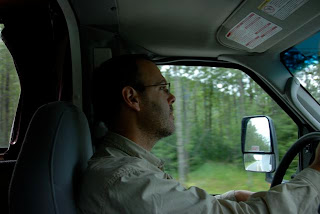
Nir driving toward Kenai Peninsula
Turnaround Pass
Turnaround Pass
We passed this region and started going down along a canyon. After a while we got to an intersection with a road leading to Hope. This is a 15 mile road riding down the mountains back toward Turnaround Bay. The city of Hope is a small city that had a major boom in the late 19th century when someone discovered gold in the nearby stream. That year the city had a mini gold rush growing to 3000 people. Today there are less then two hundred locals. We got to the city and couldn't find it. Like many Alaska towns there is no real town, but rather several driveways along the road leading into the forest, and you don't find the "center of town". We passed the town and reached a state campground where according to the book there is a nice hiking trail parallel to the bay.
We went off on the trail and saw warning of "bear territory". Soon after we encountered a couple that returned from a hike that told us they saw bear signs. We took out the bear bell and put it on the backpack and I lead the way making jingle-jungle noise. Although the trail run on the cliff above the sea, we were walking in dense brush with many berry bushes. The trail was very narrow at places and twisting, perfect scenario for surprising a bear. After a while the trail didn't clear up, and so we were left feeling that the rest of the trail is going to be like that, and we started considering going back. We then came across a local woman who was walking with her dog (a nice, very healthy labrador-like dog) and collecting raspberry. She told us that there is a black bear up ahead but we shouldn't be afraid. We immediately turned around and returned to the car.
Trail in the woods
This hiking experience wasn't so much fun, so we decided to try something else. We returned up the road and turned on a sign for a cafe. Turns out that this cafe sits on what used to be Main st in the old Hope. We went inside and had a light meal, and then went to explore the nearby stream (thinking of panning for gold). Instead of gold we found a lot of salmon. There were spawning salmon in the stream and several people trying to fish. The sky was grey and dramatic and there was a vast expanse of beach to walk through.
Gloomy sky
Roy and me practiced capturing seagulls in flight and we all searched for discoveries.
Seagulls
And more seagulls
The mud here was fine clay, probably due to the glacier dust source of it. We found many tracks in the mud, including ones that looked like large paws that we suspect to belong to a bear....
Whose track can these be?
And these tracks?
It started to drizzle, and we got the clue, and moved on. Our shoes were thick with clay, and so getting into the RV required some care. We headed back to the main road and continued down toward Seward.
Seward is a port town located at the end of a deep glacial fjord at the south-eastern end of the peninsula. It is surrounded by steep mountains on both side. These mountains are covered with large ice-fields from which multiple glaciers originate. The size of one of these ice-fields is larger than the state of Rhode Island (true a small state, but still a state). The town has a port (another one of the ports that are open all year) and a big small-ship harbor (later we heard that there is a 10-year waiting list to get a permanent spot for a boat). The general topology of the area is like Eilat, a long narrow bay with mountains on both side. The town is located roughly where you would put Eilat, on the west end of the tip of the bay. Our campground was two miles south of the town also on the west side.
Since it was raining, and we didn't have internet access for a while, we decided to stop at an internet cafe before heading to the campground. We found one in the south end of town (which turned out to be the main shop district). It was a cozy cool place with espresso drinks, smoothies, couches, and internet. The kids checked their mail and then read books (while sipping smoothies) and I had a coffee and dealt with some burning work related issues. At 9pm we headed toward the campsite. This meant driving along a muddy dirt road (we are used
to that :-) ) and reaching a nice site that has ocean front office with a large common space (warm fire place and free tea and coffee).
Lior on Miller Landing Beach
Miller Landing Beach
Our site was in the woods in the back, next to the showers and laundry. We started some laundry cycles and had dinner. After showering and taking care of the cloths we went a sleep late.
Map:


No comments:
Post a Comment